We’ve seen over the last week that the new ocean layer in Google Earth 5.0 is a useful tool for visualization and presentation. DSN readers have commented that GE could also be useful for research, if one were to geo-reference scientific literature, for example. This updated REPOST from July 2008 gives an example of one small application for GE, mapping 19th Century Voyages.
I am currently studying deep sea-fans, or gorgonians, in the West Atlantic mesophotic or “twilight zone” between 50-150 m. Many of these gorgonians have their first description in the reports by Wright and Studer (1889) of the HMS Challenger Expedition 1873-1876. The main difference between then and now is that 19th century biologists studied dead and broken colonies dredged or trawled from the abyss, while modern scientists use submersibles and ROVs to study the organisms in their natural habitat, in all their living splendor.
Certain features of my animals are well illustrated, but the descriptions are dry, with no in situ photographs. We have no idea what these gorgonian colonies looked like when they were alive. This is necessary so we can identify them in-situ. So, I’m seeking historical background to put the HMS Challenger observations in context. Like a modern guy, I quickly turn to Amazon for background material (books) and Google Earth for a visualization (maps).
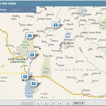
As a deep-sea biologist, the first thing I need to know is “where did the HMS Challenger collect their samples, exactly”? This is a simple map based function. The chances I will find the Challenger Expedition on Google Earth are good thanks to “Hill” a “Master Guide” at Google Earth, and a professed Google Earth “addict”. He’s uploaded and georeferenced the maps to this website so I can tell at a glance where the Challenger has been, and where they’ve not.
In a way, the Challenger Expedition could come alive again in a “Google Ocean” environment. An online expedition today could incorporate georeferenced text, photos, audio, and live video, plus graphics and animation to help illustrate these bizarre and fascinating benthic habitats. This is what you’ll see when you explore the new ocean layer in GE 5.0. If you’re interested in learning more about the Challenger Expedition, search the H.M.S. Challenger Library at 19th Century Science.
I see lots of room for improvement to this unique format and presentation, but it makes me wonder, how can I see more of this kind of thing on Google Earth? Where will it develop and grow? And, when was the last time we sent a ship around the world collecting deep-sea samples for such a broadly interdisciplinary group of scientists?