

Deep Sea News “field correspondent” and good friend Wallace J Nichols is posting links to the first real evidence of Google Earth enhancements. Click here to read today’s blog post about the new contribution from Seaturtle.org. Links at the bottom take you to videos that play through the migration track of J’s first tagged turtle, Adelita, who journeyed from Baja to Japan over the course of two years.
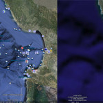
What’s the first thing you notice in the background? Improved seafloor bathymetry. This is presumedly the 4km satellite derived product from Smith and Sandwell (Science, 1997). Scripp’s scientist David Sandwell had been quoted several times in ‘leaked” articles over the last months. The first thing you notice in the foreground? The actual migration route of a loggerhead turtle! From Wildlife Tracking.org:
Adelita was the first turtle ever tracked across an entire ocean basin using satellite telemetry…maybe even the first marine animal! Millions of kids shared her migration on the internet. … She reminds us that the oceans are connected and that we need to work together to protect sea turtles and their habitat.
Needless to say, Google Earth’s improved ocean resolution will be a powerful new tool for marine science, conservation, and education. As stated by Senegalese poet and naturalist Baba Dioum, “we will protect only what we love. We will love only what we understand. We will understand only what we are taught.” This new tool should be a treasure to teachers online everywhere.
As I mentioned earlier, insiders are telling Deep Sea News to “watch NBC Nightly News tonight.” We obviously don’t pay them enough.
UPDATE: Google Earth 5.0 is available for download. Look for the “Ocean” tab in Layers and click “Explore the Ocean” to hear Dr. Sylvia Earle’s unique and inspired narration. She’s the perfect ambassador for a sea change in our treatment of this ocean planet. Read her Message for the Oceans if you’re looking for more of her enlightened philosophy.


More detailed coverage from the Guardian after its initial story:
http://www.guardian.co.uk/environment/2009/feb/02/google-earth-oceans
http://www.guardian.co.uk/environment/2009/feb/02/pen-hadow-arctic-ocean-google-earth
http://www.guardian.co.uk/environment/video/2009/feb/02/ocean-google-earth
http://www.guardian.co.uk/environment/gallery/2009/feb/02/google-earth-ocean?picture=342662938
Thanks for the info. Very exciting.