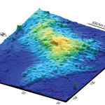
This is a perspective view of the Kawio Barat (West Kawio) seamount looking from the northwest. The underwater volcano rises around 3,800 meters from the seafloor. Credit: Image courtesy of INDEX 2010: "Indonesia-USA Deep-Sea Exploration of the Sangihe Talaud Region."
The join Indonesia – U.S. exploration of the deep ocean north of Sulawesi, Indonesia mapped the large undersea volcano Kawio Barat. From base to summet Kawio Barat measures 10,000 feet but its summit still remains 8,000 feet below the surface. The expedition also utilizing telepresence to connect researchers on land to the NOAA ship Okeanos Explorer. Researchers at the Exploration Command Centers in Jakarta and Seattle can interact with shipboard personnel to guide the expedition via live satellite and high-speed internet. You can catch the expedition at oceanexplorer.noaa.gov in both English and Bahasa Indonesia. The site includes logs from scientists at sea and ashore, images from the expedition, and expedition education lesson plans.
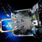
Close-up imagery showing barnacles covering sulphur structures on Kawio Barat volcano. Their tentacles, or ‘cirri,’ extended like blooming flowers, then folded back into the shell. The white fluff on the cirri are filaments of bacteria that grow in the passing vent water. The barnacles hold them out to improve growth then, apparently, withdraw to “lick their fingers.” Credit: Image courtesy of INDEX 2010: "Indonesia-USA Deep-Sea Exploration of the Sangihe Talaud Region."
Share the post "Update on NOAA Expedition in the Indian Ocean"